
What is Wundermap?
WunderMap is an interactive online map platform that provides real-time weather data and information on a global scale. Developed by Weather Underground, a commercial weather service provider, WunderMap allows users to access various weather-related information including temperature, precipitation, wind speed, and other relevant weather metrics.
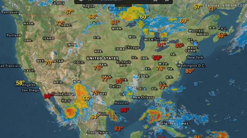
WunderMap uses data from a network of weather stations, radars, and satellites to provide detailed and accurate weather information in real time. Users can zoom in and out of the map to view weather patterns and conditions at different locations and also access various overlays such as radar images, satellite imagery, and temperature contours to get a more comprehensive view of weather conditions.
In addition to providing weather information, WunderMap also allows users to submit their own weather reports, photos, and videos, which can help provide more localized information to other users. With its user-friendly interface and comprehensive data, WunderMap has become a popular tool for both amateur and professional weather enthusiasts alike.
History of Wundermap
WunderMap was developed by Weather Underground, a commercial weather service provider that was founded in 1995 by a group of meteorologists at the University of Michigan. Weather Underground initially provided weather data and forecasts for a small number of locations but quickly expanded its services to cover a global network of weather stations and sensors.
In 2005, Weather Underground launched its first interactive weather map, which was called “WunderMap”. The map provided real-time weather information and allowed users to zoom in and out of different locations to view weather conditions. Over the years, WunderMap has been updated and improved with new features and more accurate data, becoming one of the most popular weather maps available online.
In 2012, Weather Underground was acquired by The Weather Company, a subsidiary of IBM. The acquisition allowed Weather Underground to continue expanding its services and improving its technology, including the development of WunderMap. Today, WunderMap is used by millions of people around the world to access up-to-date weather information and track weather patterns in real-time.
Importance of Wundermap for weather enthusiasts
WunderMap is a crucial tool for weather enthusiasts, providing them with real-time and accurate weather information to better understand and track weather patterns. Firstly, it allows users to view current weather conditions in different areas, such as temperature, precipitation, and wind speed.
By zooming in and out of the map, users can quickly see the conditions across an entire region or focus on a specific location. Secondly, WunderMap also provides access to weather radar images, satellite imagery, and temperature contours, which can help weather enthusiasts gain a more comprehensive view of weather conditions.
In addition, WunderMap allows users to submit their own weather reports, photos, and videos, creating a community of weather enthusiasts who share information and insights about the weather.
This community-generated data can provide valuable localized information that may not be available from traditional weather sources. Moreover, WunderMap can be used for monitoring and tracking severe weather conditions, such as hurricanes, tornadoes, and severe thunderstorms, providing critical information to those who may be in the path of dangerous weather.
Overview of Wundermap Features
Wundermap is a weather visualization platform that provides users with a comprehensive view of the weather in their area. The platform offers a wide range of features that allow users to access real-time weather data, track weather patterns, and receive alerts about severe weather events.
1. Displays Current Weather Conditions
Wundermap displays real-time weather conditions for a given location, such as temperature, humidity, wind speed, wind direction, and more, using colorful and easy-to-understand icons. This allows users to quickly get an idea of the weather conditions in their area.
2. Provides Radar and Satellite Imagery
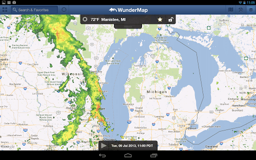
Wundermap offers radar and satellite imagery that allows users to track weather patterns and predict incoming storms. The radar imagery shows precipitation, while the satellite imagery shows cloud cover. Users can choose between different layers of radar and satellite imagery to get a more detailed view of the weather.
3. Offers Zoom and Pan Options
Wundermap allows users to zoom in and out of the map and pan across different locations, giving them a comprehensive view of the weather conditions in a specific area. This feature is particularly useful for those who want to explore weather patterns in different locations.
4. Displays Weather Layers
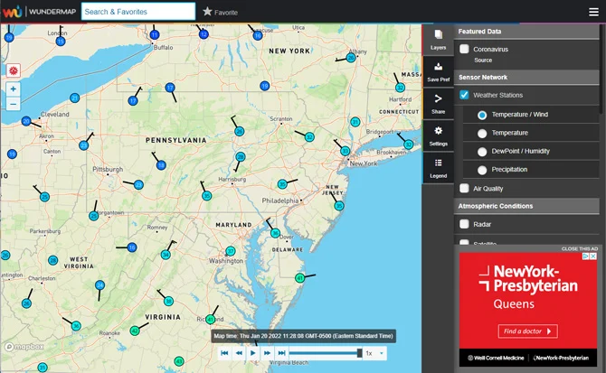
Wundermap offers different weather layers that users can choose to display, such as temperature, precipitation, and wind speed. Users can also toggle different layers on and off to customize the map to their liking. This feature allows users to see the weather conditions in a specific area in more detail.
5. Offers Customization Options
Wundermap provides customization options, such as choosing the color scheme, map style, and font size, to cater to users’ preferences. This feature allows users to personalize their experience and make the map more accessible and easy to read.
6. Displays Severe Weather Alerts
Wundermap displays severe weather alerts, such as tornado warnings and hurricane alerts, to help users stay informed and safe. The alerts are color-coded based on the severity of the weather event, and users can click on the alerts to get more information.
7. Provides Weather Forecast
Wundermap offers a weather forecast that provides users with an idea of what the weather will be like in the next few hours or days. This feature is particularly useful for planning outdoor activities and events.
How to use Wundermap?
By using the following simple steps, you can use Wundermap to stay informed about the weather conditions in your area.
- Open Wundermap: Go to the Wundermap website or download the mobile app and open it.
- Search for a Location: Type in the name of the location you want to view in the search bar. You can also search for a specific address or ZIP code.
- View Current Weather Conditions: Once you’ve selected a location, the map will display the current weather conditions for that area, including temperature, humidity, wind speed, and more. You can also see the time of sunrise and sunset.
- View Radar and Satellite Imagery: To view radar and satellite imagery, click on the “Layers” icon in the top left corner of the map. You can choose to view radar, satellite, or a combination of both.
- Customize the Map: To customize the map, click on the “Settings” icon in the top right corner of the map. From there, you can choose the color scheme, map style, and font size.
- View Weather Layers: To view different weather layers, click on the “Layers” icon and choose the layer you want to view, such as temperature, precipitation, or wind speed.
- Zoom and Pan: Use the zoom and pan features to explore different areas of the map. You can zoom in and out using the “+” and “-” icons in the top left corner of the map, and pan by clicking and dragging the map.
- View Severe Weather Alerts: To view severe weather alerts, click on the “Alerts” icon in the top left corner of the map. The alerts will be color-coded based on the severity of the weather event.
- View Weather Forecast: To view the weather forecast, click on the “Forecast” tab at the bottom of the map. You can view the forecast for the next few hours or days.
- Access Historical Weather Data: To access historical weather data, click on the “History” tab at the bottom of the map. You can view data from the past week or month.
- Report Community Weather: To report community weather, click on the “Report” icon in the top right corner of the map. You can report weather conditions in your area to help others stay informed.
Limitations of Wundermap
While Wundermap is a useful tool for accessing weather information, it does have some limitations:
1. Limited Coverage
While Wundermap covers a large area, some regions may have limited or no weather data available. This may be due to a lack of weather stations in certain areas, or because the data is not publicly available.
2. Data Accuracy
Wundermap uses a variety of sources to collect weather data, including government agencies, private weather companies, and individual weather stations. However, the accuracy of the data can vary, and users should be aware that the information may not always be 100% accurate or up-to-date.
3. Device Compatibility
Wundermap is available as a website and a mobile app, but it may not be compatible with all devices or operating systems. Users should check the platform’s compatibility with their device before using it.
4. Learning Curve
Wundermap has a variety of features and customization options, which may take some time for users to learn and fully utilize. Some users may find it overwhelming at first, especially if they are not familiar with weather forecasting tools.
5. Data Overload
Wundermap provides a lot of information, which may be overwhelming for some users. It’s important to focus on the most relevant data for individual needs and not get bogged down in unnecessary details.
6. Language Limitations
While Wundermap is available in several languages, it may not be accessible to non-English speakers who are not familiar with the language used on the platform.
Wundermap vs Other Weather Apps
Wundermap is just one of many weather apps available on the market. Here are some key differences between Wundermap and other weather apps:
Visual Representation
Wundermap provides a visual representation of weather data, which can help users understand weather patterns and trends. Other weather apps may provide this information in a more traditional text or numerical format.
Customization
Wundermap allows users to customize the map to their preferences, including color schemes, font size, and map style. Other weather apps may not offer as many customization options.
Historical Data
Wundermap provides access to historical weather data, which can be useful for research purposes or for planning future outdoor activities. Some other weather apps may not offer this feature.
Community Reporting
Wundermap allows users to report weather conditions in their area, which can help others in the community stay informed about local weather conditions. Other weather apps may not offer this feature.
Accuracy
While all weather apps rely on weather data from various sources, Wundermap uses a variety of data sources to provide a comprehensive view of weather conditions. This can make it more accurate than other apps that rely on only one or a few data sources.
Price
Wundermap is a free platform, while some other weather apps may require a subscription or in-app purchases to access certain features
Conclusion:
Wundermap can be a valuable tool for anyone who wants to stay informed about weather conditions in their area. Its customizable map and comprehensive weather data can help users understand weather patterns and make informed decisions about their daily activities. While Wundermap may not be the only weather app available, its unique set of features and customization options make it a valuable tool for anyone who wants to stay informed about the weather in their area.
- Kubernetes vs Docker: Which One Do You Need in 2026? - June 24, 2026
- FlexClip AI Long Video to Short Video Review - June 17, 2026
- The Screen Is the New Casino Floor - May 15, 2026